Hello everybody, I am María Fuentes Martínez, this
week I am the Analyst and I have had to evaluate each member of our group as
well as the work of the whole group. Moreover, I have to answer some questions
related with this second practice: “Treasure hand: cartographic projections”
a.
What was the best part of the
activity?
The best part of the activity was the
concepts that we have learnt, because none of us knew that the countries shown
on maps and that have always been taught us in school, college ... are
distorted and does not show the whole reality. We have really enjoyed
researching and comparing countries, and investigating which of them are bigger
or smaller with the use of map projections (Robinson, Mercator and Azimuthal).
b.
What was the worst?
From my point of view, the worst of
this activity has been the beginning, that is, knowing how to begin and how to
route the activity, since none of the members of the group had some knowledge
about the different types of projections and the types of distortions that
media produce. Before carrying out and investigate about this activity, the
panic enters in our group and it was a kind of "chaos", nobody knew
what to do or where to start...
This "chaos" was produced because at school or at high school no one had taught us the distortions that could produce the maps, we simply were teach geography using a type of map, mercator or robinson in my case. From the first cycle of primary, students begin to use maps in order to extend the geographical space that they known. In addition, the teacher must know the elements of a map including the different types of projections and let them know their students.
But finally came the order into the group and everything has
been find. Have you ever heard that you should always be willing to learn and acquire new knowledge as future teachers? Well, that did us.
c.
What was the best moment of the week
(in the work of the group)?
The best moment of the week has been
our own behavior, I mean, our faces fascinated to see that the surfaces of the
countries do not correspond to the size of these countries appears in the maps.
We considered very interesting the different projections used that nobody had taught to us before, to test these
differences.
d.
What have you learnt?
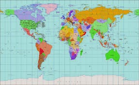
We have learnt that there are
different types of media that distort the reality and how these distortions
affect learning. We could see it more
practically through different map projections, some geographic principles that
permit us to differentiate the real and non real world.
In addition we also have seen the incompetence of some teachers, who have not taught us the distortions that occur in the different projections and which I consider important. We now learn at university, for example, that the area of Africa is about 14 times that of Greenland, and the in the Mercator projection Greenland appears about the same size of Africa.
Teachers must act as a filter of all the information that comes to the students. We also have to think about how the resources we use affect the vision that students have about reality. Reality has different interpretations, teachers must teach students the highest number of possible interpretations so that they be able to understand others who don´t think like them. For example the fundamentalists of any religion, the Nazis ... get a very distorted and closed education, which does not focus on the reality in which we live, but only part of it (they only are taught a part of reality).
e.
What do you need to conserve -as a
group- for the next weeks?
We are a united group and we have a
good organization, although we work in different ways and each of us have
different opinions, we use this diversity of opinions to enrich our work. The
opinion of each of us is taken into account and our base as a group is the
trust we have in all of us.
f.
What do you need to improve –as a
group- for the next weeks?
What we need to improve as a group
is the availability of each of us to meet together to do the work. Because of
extracurricular activities we cannot meet all together and we are always
missing someone when we meet for doing a practice. Thus we need to distribute
the work and it is a little more complicated to work.
g.
How THIS content is related to other
contents in the course and in your degree?
During this first year of the degree
there are not any subjects in which the contents related with the practice
Treasure Hand are given. But in the following years we will be given Geography
in which we will surely seen maps from different projections that we have
learned in this practice.
h. There is any evident social
connection of this content (news, politics, etc.)?
Some media offered us distorted
pictures of reality, for example in many magazines appear images that have been
retouched through different programs. The Photoshop is an example of program that
distorts the reality. Now if you want to see how the Photoshop transforms a
woman in 38 seconds check this link:
Moreover, we have been researched on
the internet and we have found images of blue trees or elephants with a peak,
which also have been retouched with Photoshop. This distortion of the reality
can cause confusion in children.
On the other hand in the political sense, news, tv brands with informational and associated programs, newspapers and magazines tend to give their particular view depending on the ideology or the funds they receive from certain political parties or brand advertisers .
In the books something similar happens, depending on the publisher and responsible for funding the book, the contents vary from other textbooks. For example when we talking about the history of Spain and Franco. Today textbooks explain that historical facts have economic, political and social causes. Different interpretations of the facts are given and it is explained that historians construct them.
Futhermore, all the analysts have done an explanation of the distortion of the reality, and how media distort it.
As I have mentioned before, I have had to grade
each member's work, using the following rubric. I'll rate from 1 to 5 depending
on the involvement and responsibility in the group.
|
Trini Mª Albert Palazón
|
Lola López Serrano
|
Eva García García
|
Marina Garcerán Conesa
|
Alba Marín Cano
|
Carolina Eva Gómez de Cecilia
|
Miriam Gamuz Gea
|
Implications in the group
|
5
|
4
|
5
|
3
|
4
|
5
|
3
|
Creativity in the contributed ideas.
|
5
|
4
|
3
|
2
|
3
|
5
|
3
|
Collaboration: helps when she is needed
|
5
|
5
|
5
|
3
|
5
|
5
|
4
|
Good work
|
5
|
5
|
5
|
3
|
4
|
5
|
3
|
Punctuality when we meet together to do the
practice
|
5
|
5
|
5
|
5
|
5
|
5
|
5
|
Endeavour
|
4
|
5
|
4
|
3
|
4
|
5
|
4
|
Final Grade
|
29
|
28
|
27
|
19
|
25
|
30
|
22
|


.png&container=blogger&gadget=a&rewriteMime=image%2F*)

.png&container=blogger&gadget=a&rewriteMime=image%2F*)
.png&container=blogger&gadget=a&rewriteMime=image%2F*)
.png)
.png)
.png)